

LIFE AT THE TOP
AUSTRALIA’S Top End in the Northern Territory is an ANCIENT and EXTREME landscape best DISCOVERED through slow steps rather than sizable treks; Litchfield and Kakadu National Parks are JEWELS in the crown
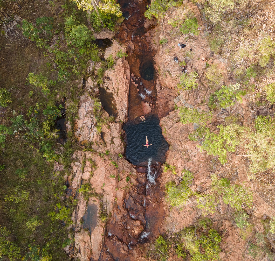
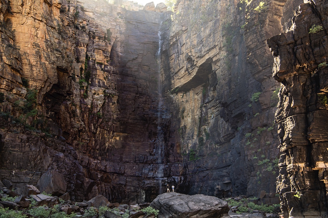
 After an arduous, mile-long boulder scramble beneath the baking Australian sun, the beach feels like a mirage. White sand and mercifully crocodile-free waters framed by tropical freshwater pandanus shimmer into view at the base of a towering sandstone escarpment in Kakadu National Park.
ROADS IN
I strip off my hiking boots and wade into the cold, clear water of the mini oasis — a welcome respite after a hot hike. As I shield my eyes from the harsh sun in the flat, blue sky, I gaze up at the dark watermarks on the sandstone cliffs either side of me. Since indigenous Australians first inhabited this land around 60,000 years ago, the Northern Territory’s Top End has been a place where it pays to be able to read the landscape, to understand the signs of what’s to come. “In a few months,” my guide says, gesturing to the beach, the boulders, and the plunge pool beneath the 200m-high Jim Jim Falls another 20m on, “this will all be underwater.”
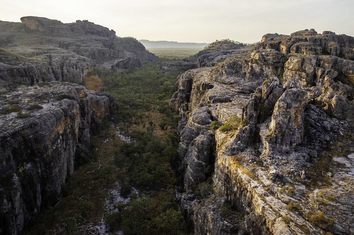
It’s hard to believe now, with the falls just a trickle during the dry season (May–October), but it won’t be long before monsoons turn the trickle into a torrent and the hike in becomes impassable to all but crocodiles and their prey. It’s a transformation that takes place right across the 7,722 square miles of Kakadu National Park and beyond, as roads and trails are cut off and expanses of arid, savannah woodland morph into lush, freshwater wetlands under heavy, grey clouds.
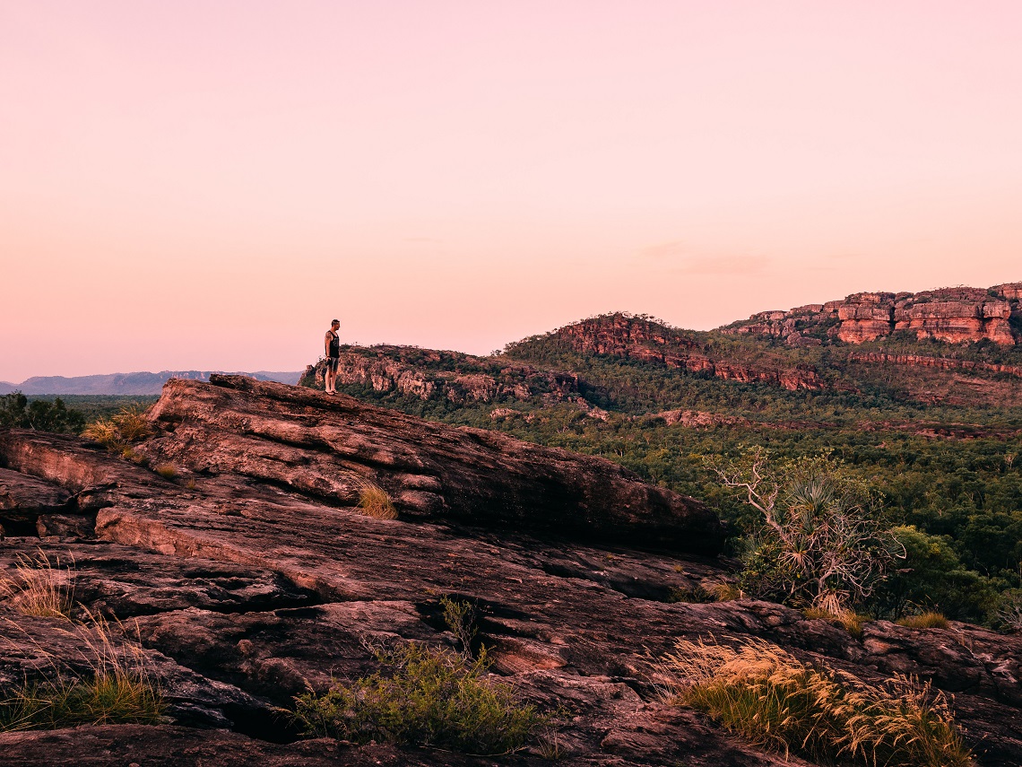
From a human’s perspective, this annual metamorphosis makes this part of the world seem like a shifting landscape. An ever-changing place of swinging extremes. But it’s been 140 million years since the sandstone escarpment that forms the edge of the plateau of Kakadu’s eastern border rose from the sea to create the spectacular scenery adventure-seekers hike through today — and it will remain silently standing for many, many millions yet to come.
The thought alone is enough to make you feel more like dust in the wind than a determined hiker with a destination. The Top End is terrain that’s impossible to conquer, to complete. It’s not somewhere to measure your experience in distance trekked or elevation climbed. This is a land that requires slow steps. For you to sink in and sense your place in the world, and hopefully leave with a shift in perspective that might just change your life.
ESCAPE TO THE TOP END
If you’re looking for a shift in perspective, a pandemic is a good place to start. Being an avid traveller and hiker, I decided to take the lack of overseas travel options as a chance to explore more of my large island home — hoping to time a trip between internal border closures. Craving meaning in the midst of the madness, I was looking to connect with this land and its history in a way that felt grounded and real. I wanted to be in awe of nature and humbled by history. And I knew just the place to go.
The Ramsar Convention on Wetlands is the intergovernmental treaty that provides the framework for the conservation and wise use of wetlands and their resources. The Convention was adopted in the Iranian city of Ramsar in 1971 and came into force in 1975. Since then, almost 90 percent of UN member states, from all the world’s geographic regions, have acceded to become Contracting Parties.
The Top End of Australia’s Northern Territory covers around 94,600 square miles, with the azure Timor Sea to the north and the semi-arid Red Centre to the south. It’s made up of *RAMSAR-listed wetlands, dry grasslands, tropical rainforests, sandstone gorges and rugged plateaus. The richly diverse landscape is home to more than 2,000 plant species, one-third of Australia’s 800- plus bird species, and one-quarter of the continent’s land mammals. It’s also the location of some of the oldest rock illustrations in the world, which date back to prehistoric times, and the land’s traditional owners continue to live on and care for their home as their ancestors did.
In short, the Top End is very big, very old, and very impressive. Exploring it all in just one week was never an option. So, as a taster, I’d booked a seven-day hiking trip with Life’s An Adventure to tackle a number of short hikes in two of its most famous national parks — Litchfield and Kakadu.
Thanks to the announcement of an impending border closure in my home state of Victoria — at the opposite end of the country — my adventure began before I left the house with a last-minute flight change. I landed in Darwin, the Northern Territory’s capital, with less than 24 hours to spare before my fellow Victorians were locked out.
Beginning a trip this way meant I was already more grateful than usual for the chance to explore a spectacular part of the world and, from the moment our 4WD left the outskirts of Darwin and entered the vast, untamed expanse of the Top End, my appreciation for this wild place only grew.
TABLETOP TERRAIN
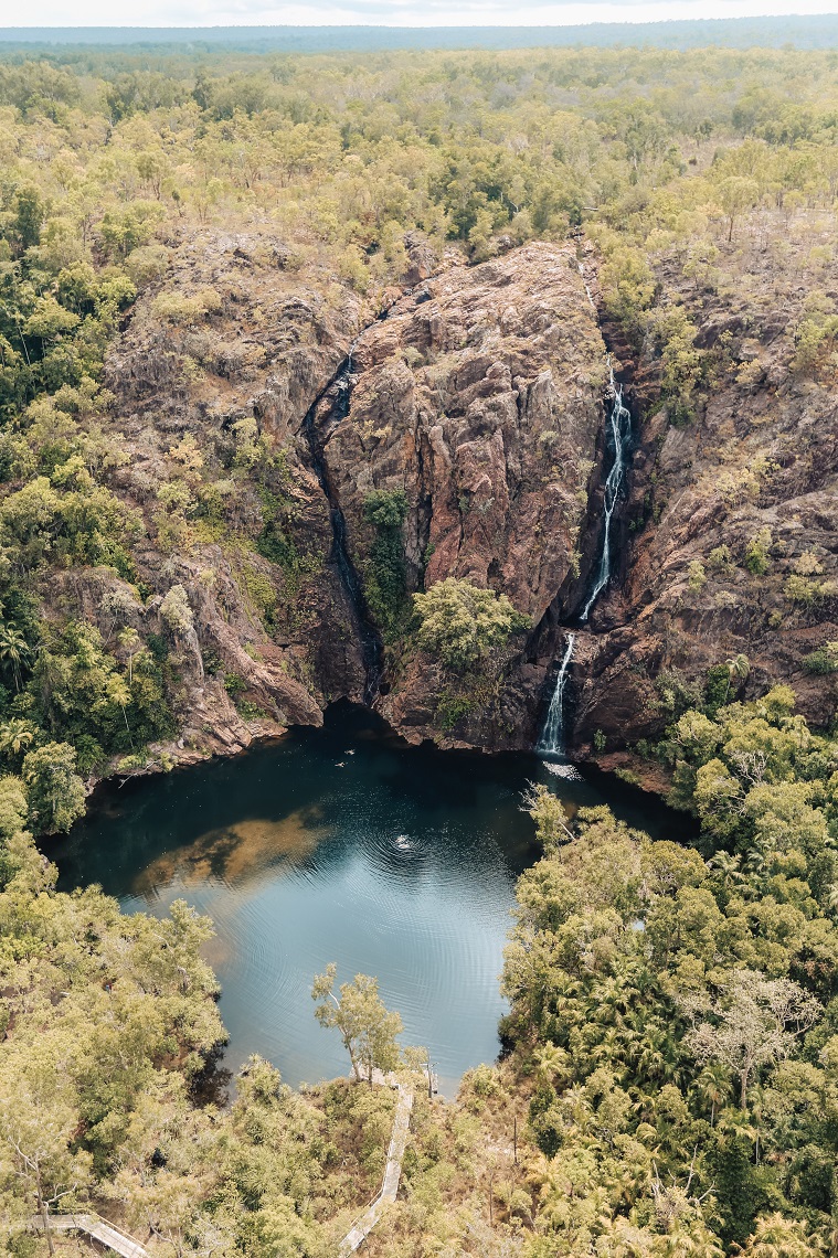
Litchfield National Park is a sandstone tabletop plateau rimmed by cascading, spring-fed waterfalls and known for its expansive views across the flat savannah woodlands that surround it. It’s home to one of the few long-distance hikes in the Top End — and one of its most challenging — the Tabletop Track.
This 25-mile circuit traverses arid landscape punctured by glistening, clear waterholes and seldom-used campground. While relatively flat, make no mistake about the difficulty of the hiking here.
Despite being winter in the Northern Territory, my trip has coincided with a particularly hot and humid dry season with temperatures reaching 38C during the heat of the day. For this reason, I’m secretly relieved to discover that today we’re only tackling a series of short sections of the Tabletop Track, to visit some of Litchfield’s most spectacular scenic spots. After a warning from our guide about one woman who missed a sign and accidentally walked 12 miles off the Tabletop Track in the blazing heat with barely any water instead of returning to her car, we set off attentively to explore Florence Falls, Buley Rockhole, Tolmer Falls, and Wangi Falls.
Throughout the day we pass from shaded rainforest, where the hundreds of chattering flying foxes dine on the jewel-red berries of Carpentaria palms, to rocky outcrops where glossy pink and black quartzite resembles scaled crocodile skin underfoot. The trails along the Tabletop Track are generally well kept and fairly flat, making it easy for the knowledgeable guides to point out significant flora as we walk, such as the Kapok tree.
These trees, with their distinctive yellow flowers, are known as a calendar plant for the local Jawoyn people. The blooms signify that the freshwater crocodiles are laying their eggs; their fruit is a sign that it’s time to collect them.
Speaking of crocodiles, hot hikes inevitably led to a craving for a cool-off. In the Top End, however, it’s inadvisable to dive right into any inviting-looking waterhole you stumble across. There are two species of crocodile in the Northern Territory: saltwater and freshwater. Or, as you’re more likely to think of them when deciding where to swim, the one that will kill you and the one that won’t. And don’t let the name fool you — the vicious and deadly saltwater crocodiles love freshwater plunge pools as much as you do.
Thankfully, at the start of every dry season, park rangers begin the enormous task of monitoring popular swimming spots for signs of saltwater crocodiles, relocating the offending reptiles if need be, and declaring specific spots officially safe for swimming. After checking the signs as well as the park’s website for this vital information, we dive into the refreshing waters at Buley Rockhole to cool off during the afternoon heat.
That night we stay in cabins at one of the many eucalypt-dotted caravan parks spread out across the Top End, emerging after dark to enjoy a blanket of stars above, the warm evening air on our skin and the not-so-distant sound of howling dingos.
KAKADU MAGIC
If you want to walk 7 miles of tough terrain in the Top End, you better start early. But beating the heat isn’t the only reason to wake before dawn. This is the time of day when World Heritage-listed Kakadu National Park reveals her magic.
Bellies full of breakfast, we jump in our 4WD to make our way to Nourlangie for the Barrk Sandstone Walk. The rising red sun soaks the woodland in warm colour, making ghostly silhouettes of the many species of eucalypts and towering termite mounds. Dingos and Antilopine wallaroos dart across the landscape, easy to spot in the almost-bare sections of recently burnt bush.
Planned burning takes place throughout the Top End and, in Kakadu, is jointly managed by Parks Australia and the land’s traditional owners. The region’s plants grow quickly after the monsoonal rains of the tropical summer. As the land dries out, this vegetation can become fuel for dangerous bushfires.
Traditional patch burning is used to clear this fuel and prevent larger, hotter bushfires. Whistling kites — also known as firebirds — take advantage of the flames, which send their prey scatting and make easy pickings. We watch as one of the fiercely intelligent raptors swoops down on a still-smouldering section of woodland, steels a small flame on a stick, and sets off to start another fire.
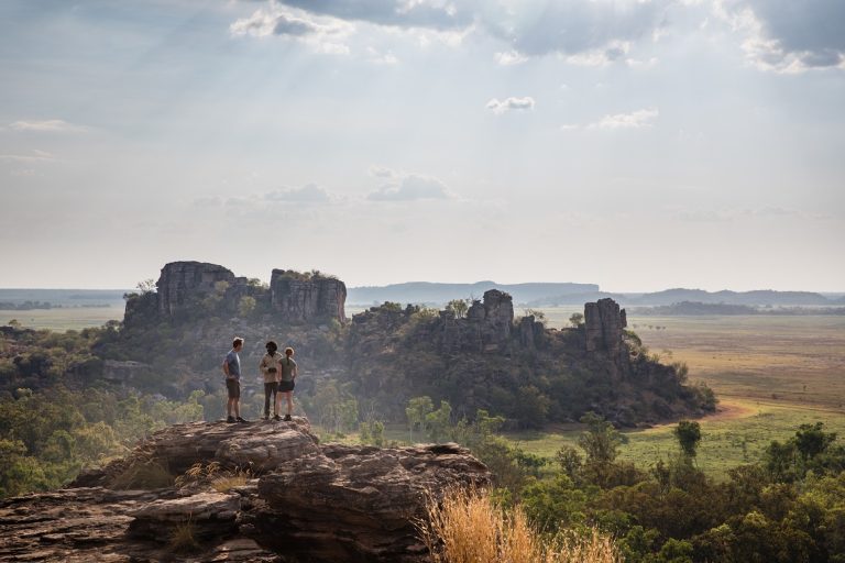
As the sun brightens and turns yellow, Kakadu’s own colours start to emerge. The soft pink haze of the flowering turkey bush, the rust-red of the oxidised sandstone, the smooth, expansive blue of the flat, wide sky. By the time we arrive at our destination, the world has begun to warm. Nourlangie is a large sandstone island standing above a vast area of surrounding woodland. Once protruding hundreds of metres out of the sea, the red slab of rock is now landlocked.
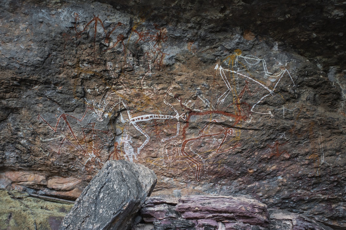
Being older than much sea life, the sandstone holds no large fossils — geologists estimate that the vast sheets of coarse sand were deposited between 1,400 and 1,800 million years ago — but it does bare the markings of a more recent history. Nourlangie is an outdoor cultural museum, home to one of the greatest concentrations of rock illustrations anywhere in the world.
We set out on our walk with 6-7 litres of water on our backs, knowing we have a climb ahead of us, but the first section of the hike begins with a gentle boardwalk. Our speed is slow here, not due to what’s underfoot, but because of the wonders on the sheer red cliffs at our sides. The rock paintings in this area document life in the region from 20,000 years ago up until first contact with European explorers. A detailed depiction of Namarrgon or ‘Lightening Man’, a Dreamtime figure who signals the arrival of the wet season in the Top End, sits beside paintings of European sailing ships and rifles.
Beyond the gallery, the walk turns into a steep climb up a rocky valley. Blue-winged kookaburras and red-tailed black cockatoos call out overhead, but we keep our eyes on the path ahead, watching for loose stones and any sign of deadly snakes. We cross a small creek, which only runs in wet season, but its seasonal moisture allows Sandstone pandanus and various ferns to cling to life.
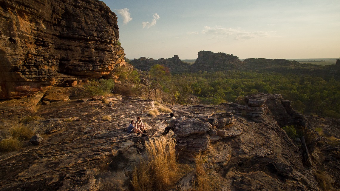
Up we climb in the steadily rising morning heat, stopping for multiple water breaks until we’re high enough to enjoy a magnificent view of the lowlands and the sheer escarpment we’re ascending. From here, the country flattens out into plateau heathland with sandy soil. Thanks to its wet season streams, it resembles the lowlands with the bright orange flowers of the Darwin woollybutt and fern leaved grevillea forming a colourful haze above us.
Soon after, we’re surrounded by stone again. Layered pillars of sandstone and conglomerate rock rise up around us like enchanted castles or the ruins of some ancient civilisation. After passing between two massive boulders and following a narrow ridge, we descend into a shallow valley. On the far side of the valley, the walk climbs up a series of rock slabs to another stunning view of the surrounding lowlands, before descending for a final time down a steep slope with large rocks and loose stones.
We reach the valley floor, legs wobbling, before finishing off the last couple of miles snaking through tall spear grass and prickly spinifex. Although this is one of the flattest sections of the walk it proves almost the hardest as, by now, six hours after sunrise, the heat is borderline claustrophobic as it radiates off the sandy track below. We’re glad to reach the 4WD and a cold drink.
CROCODILE COUNTRY
Our final few days in Kakadu are all about short walks and waterholes. There’s the boulder scramble to Jim Jim Falls — the site of the beach oasis and deep plunge pool. Here there is an option for a longer walk, the Barrk Marrlam, a challenging and steep hike that leads to the top of the escarpment and offers views over the Arnhem Land Plateau.
We also hike to Maguk waterfall and its pristine, green waterhole, which lies at the end of another difficult rock scramble scented with the sweet smell of honey grevillea. Again, you can hike to the top of the waterfall here, but we opt instead to while away an hour alternating between floating on our backs and diving below the calm surface of the cool water.
For all the water we’ve immersed ourselves in, we haven’t spotted a single crocodile floating by. This, of course, is our preference and a reflection of the incredible work done by park rangers to keep swimmers safe. But witnessing these prehistoric creatures in their natural habitat is one of the highlights of visiting the Top End and one of the best ways to do this, as well as spot the diverse and magnificent array of wetland bird species that call Kakadu home, is to jump on board an indigenous-owned-and-run Yellow Water boat cruise at sunset.
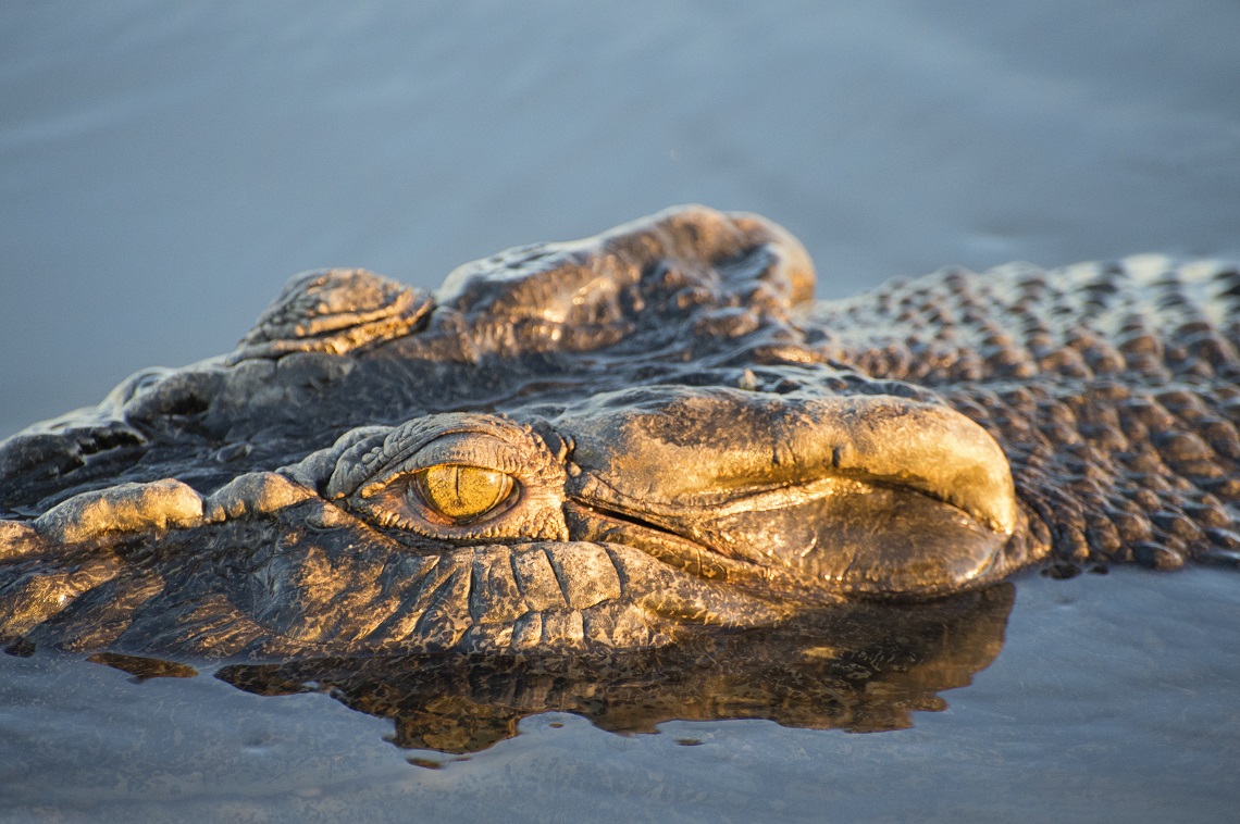
During the cruise we glimpse whistling ducks and magpie geese, white-bellied sea eagles searching for prey, and even the distinctive black-necked and red-legged Jabiru, the only species of stalk found in Australia. While these animals are magnificent, we’re all keeping our eyes out for the main event. Less than 10 minutes into the two-hour cruise the guide spots it. A four-and-a-half metre saltwater crocodile on the bank of the billabong. Jaws wide open, yellow eyes gleaming, rippling scales taut across its barrel-sized chest. I’m in awe, breath stolen by the sheer presence of the animal. I could stay in this moment forever.
Crocodiles today look the same as they did 200 million years ago. They’re described as living fossils. Perhaps that’s why I find myself humbled by the sight of one. Everything suddenly shifts into perspective. We’re all specks of dust compared to the scale and history of this land. It will all still be here long after our problems have faded to nothing. Somehow, I know that’s the realisation I came here for.
Miranda was guided by Life’s an Adventure: see www.lifesanadventure.com.au
WHO’S WRITING?
 Miranda Luby is an award-winning freelance journalist, opinion writer and author with words in National Geographic, BBC Travel and the New York Post. She lives on Victoria’s Surf Coast, Australia, where she’ll be swimming or bodyboarding most days. Find her at www.mirandaluby.com