
From the gentle green hills of the Jura, to the icy heart of the Alps, the Bern region has something to suit every hiker’s taste. Forest trails open to meadows full of flowers; there are paths through imposing gorges, around emerald green lakes, beneath waterfalls and alongside glaciers; exciting panoramic trails that take a walk in the sky, and on almost every one there will be a tempting restaurant in which to enjoy the region’s culinary delights, while gazing on romantic mountain vistas that uplift the spirits and satisfy one’s dreams.
The Faulhorn Trail
Understandably popular with those in the know, the Faulhorn Trail is a gem from start to finish, with so much to enjoy along the way that by spending a night in either Berghaus Männdlenen or the historic hotel on the summit of the Faulhorn, this long day’s walk could easily become a two-day outing.
What better way to begin than by riding the 100-year-old funicular railway from Wilderswil to Schynige Platte? Not only are views of the Eiger, Mönch and Jungfrau simply breathtaking from the station platform, but there’s an alpine garden nearby with almost 500 different plant species, and a hotel-restaurant whose terrace is the ultimate lookout over much of the Jungfrau Region.
When you can tear yourself away from these distractions, a choice of route appears: one goes ahead through a bowl of pastureland, the other angles above the alpine garden to become the Panoramaweg – a ridge walk overlooking Lake Thun and the Brienzersee on one side, and the iconic Oberland mountains on the other. These two routes come together in the upper reaches of the pastureland bowl to skirt the Laucherhorn, before continuing through a chaos of limestone rocks, ribs and cliffs to enter the moorland-like terrain of Sägistal.
Towards the upper end of this secretive little valley, the path rises across more white limestone ribs interspersed with alpine flowers, and arrives at Berghaus Männdlenen. The refreshment facilities at this small, privately-run mountain hut are welcomed by every passing hiker – especially as the next section of the trail involves a short, steep climb. This leads to yet more panoramic views, and a trail that climbs to the summit of the Faulhorn with its berghotel – the oldest in Switzerland – from which guests can enjoy memorable sunsets and multi-coloured dawns.
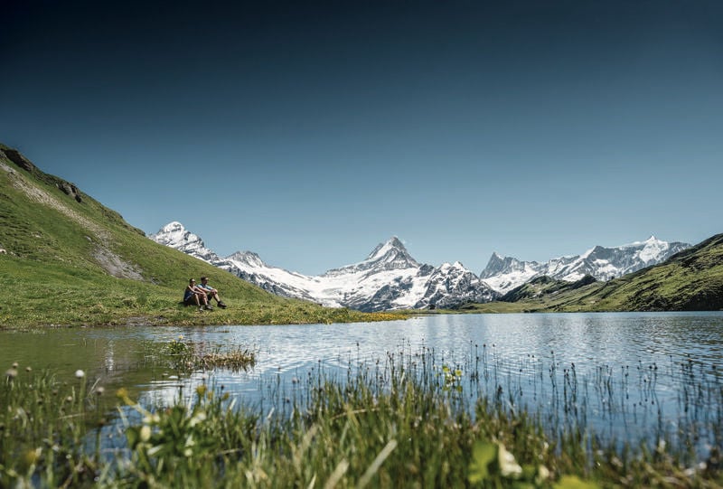
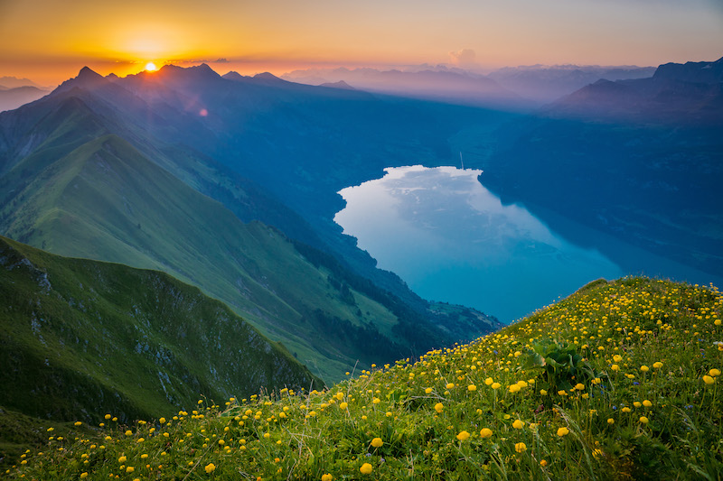
With the chain of the Bernese Alps ahead stretching as far as the eye can see, the continuing route now swoops down to a broad saddle, and down again to the dreamy Bachalpsee, a sparkling jewel of a lake that captures reflections of Wetterhorn, Schreckhorn and the distant spike of the Finsteraarhorn in its waters. This, surely, is a worthy contender for the title of ‘most beautiful lake in the Alps’.
From the Bachalpsee, a final up and down on a broad and busy path leads to the First gondola lift station. Here, you can relax with a welcome drink on the restaurant terrace, then give your legs a rest by taking a ride in the gondola down to Grindelwald.
Start: Schynige Platte
Finish: First
Time: 5-6 hours
In the Valley of Waterfalls
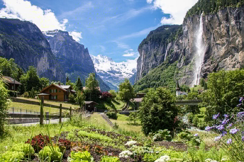
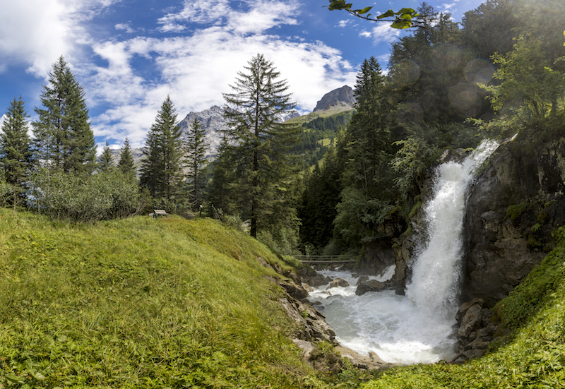
Glaciers carved the deep trench of the Lauterbrunnen valley and, on departing, left behind immense walls of rock above which Wengen, Mürren and Gimmelwald now stand. An arc of majestic, snowy mountains closes the head of the valley, while its sides are streaked with waterfalls – 72 of them, so it is widely claimed. Perhaps, you can try counting them!
The most famous is the Staubbach, as lacy as a bride’s veil spraying from the western wall, and the thunderous Trümmelbach Falls, where as much as 20,000 litres of water corkscrew through the east bank limestone per second. A walkway enables visitors to experience the raw power of nature in safety.
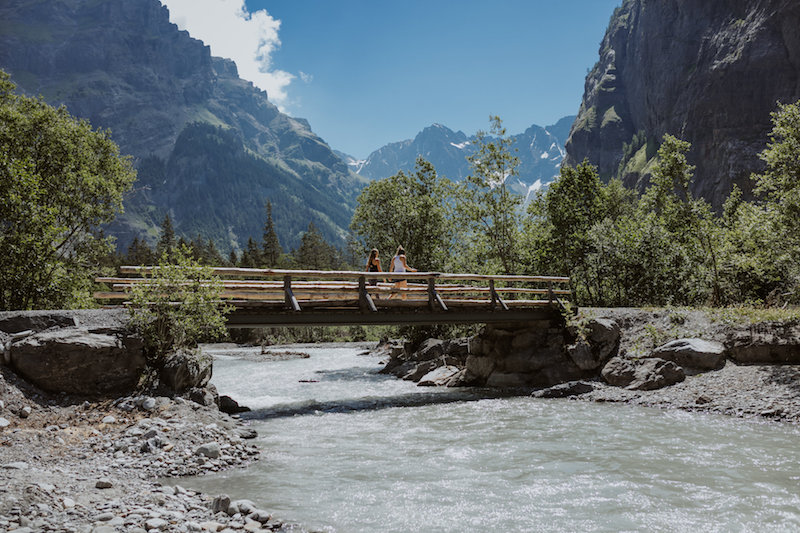
A leisurely walk along the bed of the valley will reveal much of its beauty. There’s a riverside trail for much of the way, and plenty of bus stops on the opposite bank so you can make the outing as long or as short as you like. Our preference is to start in Lauterbrunnen and walk towards the road-head at Stechelberg.
Here’s a hint: creep out of bed early and wander through the dew-damp meadows with the misty waterfalls cascading around you, and watch as dawn breaks on the Breithorn. Both Goethe and Tolkien drew inspiration from the Valley of Waterfalls. So might you.
Start: Lauterbrunnen
Finish: Stechelberg – or wherever you choose
Time: Up to 2 hours
Exploring the Gastern valley
The Gastern Valley seems untouched by the modern world. Its few buildings have a timeless charm, its forests, cliffs and meadows are just as nature intended, while the Kander river, fed by countless waterfalls, leaps over rocks with joyful abandon. Here you can wander with no set agenda and enjoy whatever the valley offers.
A minibus taxi ferries hikers from Kandersteg to Selden, whose 100 year old hotel provides simple comforts and traditional fare in an idyllic setting. It’s the perfect place from which to explore the valley. On the left bank of the river, for example, a sometimes brutally steep path climbs to the Lötschenpass in order to gain access into the Lötschental.
Up-valley beyond Selden, a track leads to the alp farm of Heimritz, where a path continues into marmot country; a region of natural rock gardens, shrubberies of dwarf pine and juniper, and tiny ‘lawns’ between the rocks. Down-valley another very steep path climbs the Gastern Valley’s left-hand wall to gain the SAC’s Balmhorn Hut, while the walk to Kandersteg in the valley bed is undemanding, but rewarding throughout.
There’s something in the Gastern Valley to meet every taste, whether you want a substantial and challenging trek with ample elevation gain, or a leisurely stroll among stunning scenery . Simply put, it’s where nature rules supreme.
Start: Selden
Finish: Kandersteg
Time: 2½-3 hours
The Brienzer Rothorn
The panoramic three-to-four hour walk along the ridge from the Brienzer Rothorn to Turren above Lungern near the Brünig Pass is one of the classic outings of the district. And no wonder. It would take about five hours to hike to the Rothorn’s 2,350m summit from the lakeside town of Brienz, but the steam-driven rack railway of the historic Rothorn Bahn is the favoured choice of most visitors, for it huffs and puffs its way there in just an hour – as it has done ever since 1892. This leaves plenty of time and energy to wander the ridge at leisure and take in the views as you go. The panorama is an extensive one that includes both the Säntis and the distant blue line of the Jura, as well as Pilatus and, just beyond the Faulhorn range, the iconic mountains of the Eiger, Mönch and Jungfrau. If those views fail to excite you, nothing will!
In settled conditions there’s nothing unduly difficult about the walk. Simply follow the ridge’s dreamy undulations towards the Höch Gumme, where you branch off to descend to Turren by one of several ways. The choice is yours to make.
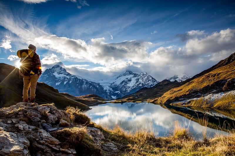
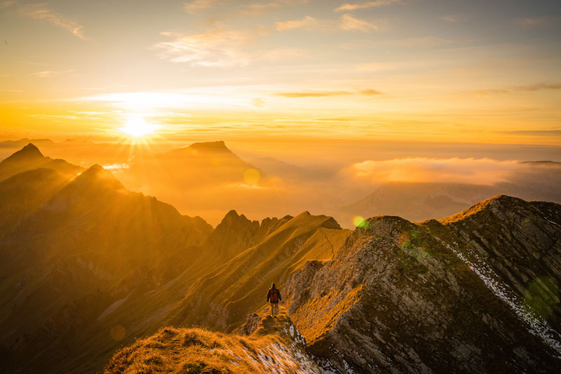
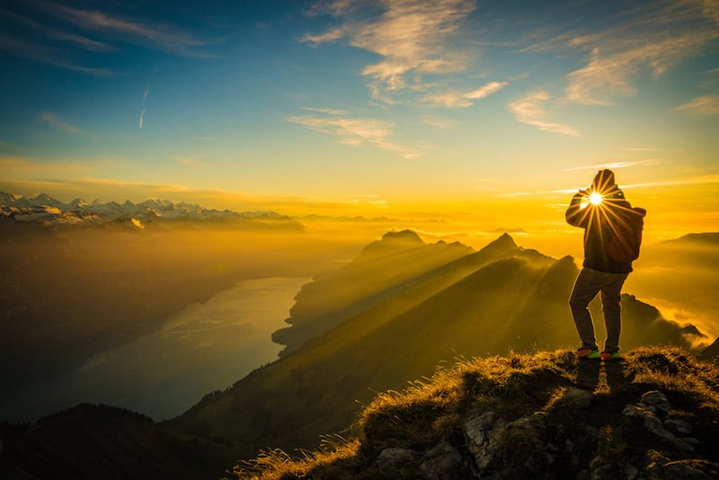
For an extra special experience, wake up before daybreak and head up onto the Brienzer Rothorn early. Once there, weather permitting, you should expect to experience one of the most jaw-dropping sunrises you might ever have seen, with the orange glow of the morning sun casting a stunning hue over the distant mountains and valleys that surround you.
Start: Brienzer Rothorn
Finish: Turren ob Lungern
Time: 3-4 hours
Ridge walk to the Augstmatthorn
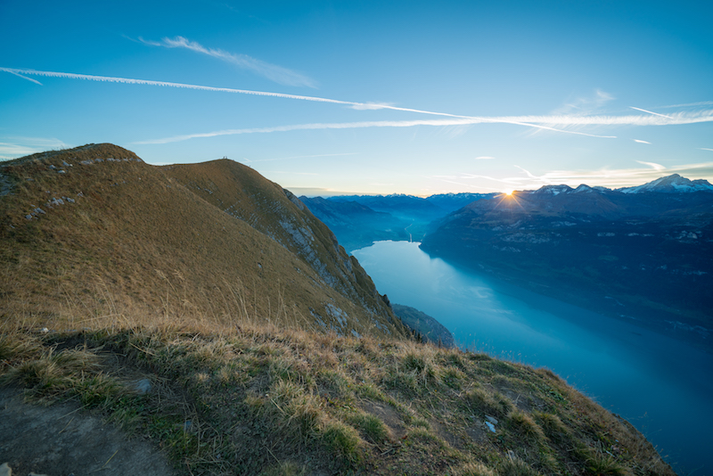
Overlooking Interlaken and the turquoise lakes of Thun and Brienz, a viewing platform 1,322m above sea level makes a wonderful vantage point, with an extravagant display of snowy mountains almost close enough to touch. And guess what… all of this reached by a simple 10-minute ride on a modern funicular railway up the pristine tree-clad slopes of the Harder Kulm.
There are plenty of walks too; one of particular interest to those who want to see ibexes in their natural habitat. It’s a moderately difficult outing which follows the wooded ridge eastward, skirting the Wannichnubel with the village of Ringgenberg far below, to reach Roteflue and Alp Horet where trees are left behind. An open ridge now reveals the district’s real beauty, and its drama. For on the cliffs and bands of rock of the Augstmatthorn, a colony of ibex display their agility without concern for hikers who study their antics nearby. Handsome creatures, with no fear of heights, they rule supreme.
Oh yes, and the views aren’t bad either. In fact, as you stand there and take in the beautifully-formed ridge, the snow-capped mountains on the horizon and the lake down below, you’ll be on cloud nine.
But be warned, it’s a steep descent from here that will test your legs on the way to Habkern via Lombachalp and Wiesenrain. At times like this, you’ll wish you were an ibex…
Start: Harder Kulm
Finish: Habkern
Time: 6 hours