
For a beautiful multi-day hike of epic proportions, you can’t go far wrong with the King’s Trail in Sweden, as Danielle Fenton finds out…
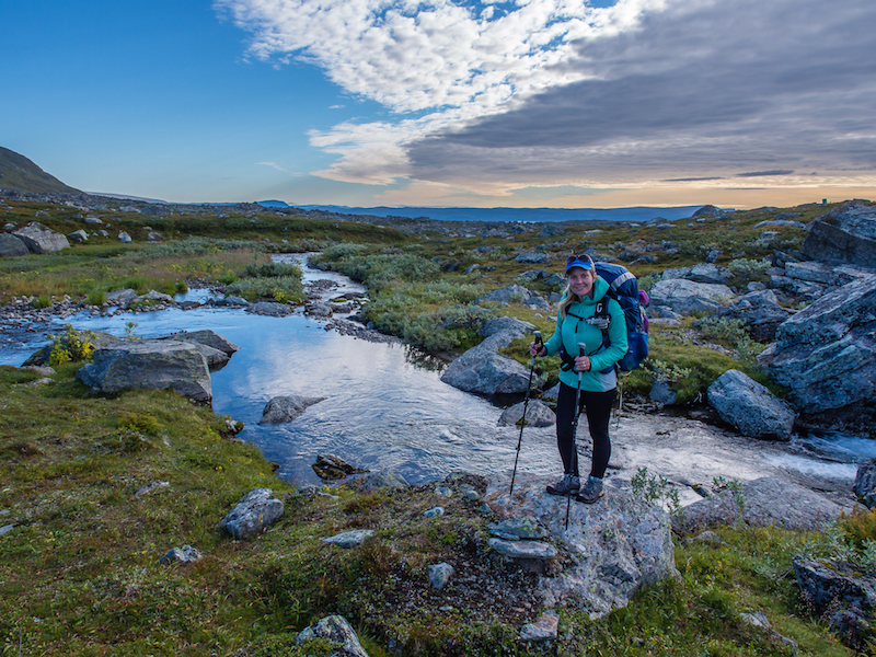
I yelled at Wayne as he plunged the wooden oar into choppy water. Spray hit our faces as the boat cut through growing waves. I hadn’t quite got used to the fact that this journey was not all on two feet, with boat crossings forming an integral part of the trail.
Thanks to his sterling rowing efforts, coupled with my attempt at navigation, we were now about halfway across Lake Teusajaure, heading for the jetty in the distance. It was late, but the wood-fired sauna at Teusajaure Mountain Hut was all the motivation we needed to get us across the last 500m. Well, that and a tin of Swedish meatballs. Never underestimate the powers of a hot meal at the end of a day of hiking.
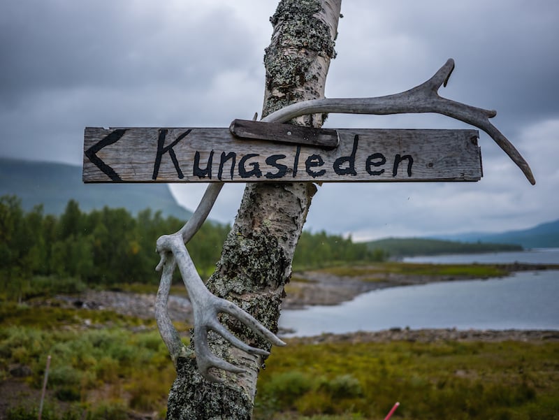
Having already crossed into the Arctic Circle, we were beginning our third week on the King’s Trail, Sweden’s premier long-distance trail that winds its way between the country’s highest peaks and through its most dramatic landscapes in the far north.
Our aim was to complete the entire 270-mile trail in 21 days, which hikers we met coming in the opposite direction seemed to think was quite ambitious. No wonder we had developed a penchant for taking time out and relaxing our muscles in a hot sauna at the end of a long day’s walk (or row). The cornerstone of Swedish culture, and a completely new experience for us on the trail, we were soon well-versed with sauna etiquette, adding them into our itinerary whenever possible.
One of the harshest environments on our planet, the Arctic has always struck us as a place for serious adventurers and experts. But the King’s Trail is do-able for a wide range of walkers, due to the relatively low altitudes, somewhat easy-going terrain, and an extensive network of mountain huts and emergency shelters along most of the route. Sleeping in the huts, making use of their cooking facilities and topping up food supplies on the go from the boutique shops, as opposed to carrying a full backpack of camping equipment and rations, means that the trip is accessible to the everyday trail seeker.
Despite its wild reputation and remote location, often described as one of the last true wildernesses in Europe, this hike is not about technical skill, but is more a test of stamina and longevity. Even if you plan to wild camp, as we did, an average hiker in moderate shape, with a taste for adventure and a good set of walking legs, can take on the challenge and go the distance.
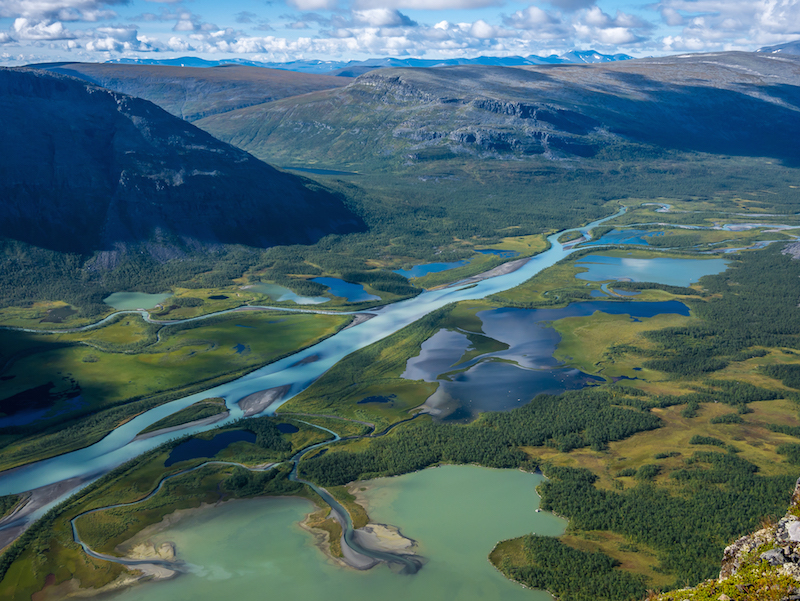
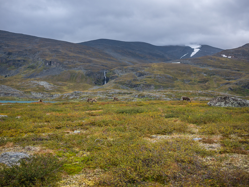
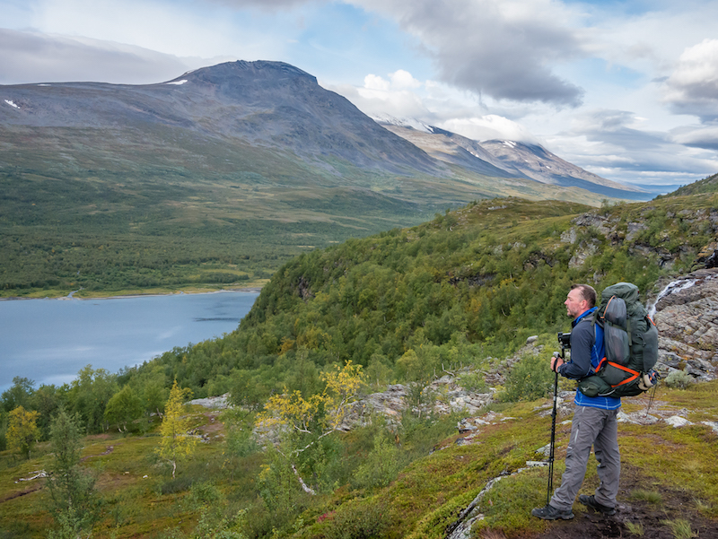
Characterised by craggy snow-capped peaks towering above perfect u-shaped valleys carpeted in light shades of green, the tremendous landscapes of the King’s Trail are reminiscent of western fells back home in the UK, except these glacial valleys are much bigger and on a far grander scale – like the Lake District on steroids. Except that in the Lake District you are not woken up by a herd of reindeer foraging around your tent.
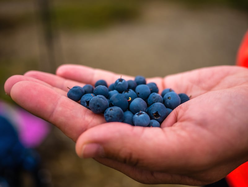
The tinkling of bells from these timid, camera-shy creatures was one of the best wake up calls we have experienced thus far on our hiking endeavours. We quickly discovered that reindeer are the commonest sighting on the trail (but the most difficult to photograph), closely followed by wild blueberries that at the time of our trip were ripe for picking. This meant we could supplement our 21-day diet of dried and tinned food with one nutritious superfood. On days when hiker hunger knew no bounds, those plump balls of juiciness really did keep us going.
Another plant we became familiar with was the dreaded bog cotton. Spotting these fluffy white heads alongside the trail is a sure sign of boggy ground, to be avoided when looking for a camping spot. But boggy ground is also the best place for cloudberries, which we thought tasted a bit like tomatoes. To our dismay this year was a bad harvest for Sweden’s national symbol and prized treasure so, in a forested canopy, we turned our attention to something else growing in abundance.
“Shall I pick it?” I asked Wayne, our inherent hunter-gatherer skills quite inept at helping us decide whether the giant mushrooms were poisonous or edible. It was a topic of great debate between passing hikers – apparently the wild mushrooms that grow along the King’s Trail are delicious added to soup. But even with some shared local knowledge and a few tips on what to look out for, we were dubious about picking and cooking them. So we gave up on mushrooms, avidly looking for signs of animal tracks from the big three of Swedish fauna instead.
We’d had a distinct lack of brown bear sightings during our time in the backcountry in the US, so we were sincerely hoping to catch sight of a bear, lynx or wolverine. But people rarely get to see these elusive creatures. A more likely sighting, although still very difficult, is the iconic, majestic forest dweller – the moose (or elk as we call it in the UK).
Sweden has the densest population of moose in the world, and it is the country’s largest mammal. Despite having keen eyes and ears, we didn’t glimpse any of the big three. But we did see what we concluded to be a pile of bear scat along the trail, plus a large moose with its calf, albeit from a distance when we stopped for a tea break at the Kaitumjaure Mountain Hut.
Passing through traditional reindeer herding land used by the Sámi, the indigenous people of northern Europe, is one unique element of this trail, but there are several others. Witnessing either the midnight sun, or the amazing phenomenon of the northern lights, nature’s own light show, dancing up above on a clear night is sure to be high on people’s list of expectations. As we finished hiking at the start of September we weren’t lucky enough to see the aurora blazing across the Arctic sky.
Yet deep into Swedish Lapland, towards the later stages of our hike, we did get spectacular changing shades of scarlet, orange and red as the entire sky seemed to light up and intensify right above our tent. After some particularly dreadful weather at the start of our trip, where we spent several nights cocooned in our sleeping bags listening to the pelting rain, it was magical to sit outside the tent and soak up the special atmosphere. It also felt quite strange to see the sun set for the first time, as at the start of our hike back in August we never seemed to experience darkness at all.
But by far one of our favourite aspects of the King’s Trail was Sweden’s Allemansrätten – the right to roam. This meant we had a fantastic choice of wild camp spots with incredible views, without the worry of being moved on or having to pitch late and leave early. One of our favourites was on a side trail above Aktse, overlooking the magnificent Rapadalen valley, when we decided to take a detour to the look-out atop Skierffe.
We couldn’t believe our luck at finding a pre-used site with a ready-made fire-pit that provided us with wonderful 360-degree views, and apart from sharing this space with a family of reindeer we had it all to ourselves. In fact, we didn’t see another soul for an entire day which is quite unusual for this well-trodden trail, but maybe an advantage of hiking northbound.
In contradiction to the norm, hiking the King’s Trail south to north was more appealing to us for several reasons. First, the sun would be on our backs and not in our faces, which is both better for photography and for charging batteries with solar panels. Further reasoning was that our bodies would have time to get accustomed to the rhythms of the trail by the time we reached what are considered the tougher sections in the north, making us fitter and stronger to handle them.
The scenery is also regarded as more spectacular in the north, so we would be saving the best until last. Most importantly, by starting in the south we avoided being part of the caravan of walkers on the Kebnekaise Circuit (the northernmost part of the trail is the most popular as hikers take a detour to summit Sweden’s highest mountain, the 2,106m-high Kebnekaise). We would also bypass the hordes of hikers taking part in the annual Fjällräven Classic event.
With a population of nine million in a country around twice the size of the UK, days can be spent exploring the wilds undisturbed, but the sense of solitude is never more apparent than when the King’s Trail leads into the inhospitable Sarek National Park. Its sheer vastness and remoteness can be overwhelming, the trail taking you to what feels like the end of the world. The most dramatic and grandiose of all of Sweden’s national parks, Sarek cannot be accessed by road. It is very much still a wild frontier, and the Swedes want to keep it this way.
Like at the start, our final week on the trail was a mixture of low cloud and steady rain, but it did not hamper our progress as by now we were trail fit and looking forward to a celebratory meal and beer in Abisko. The thought of a final sauna at the Alesjaure Mountain Hut to refresh us before the last 22-mile stretch was good motivation too, and we were confident we’d finish the whole trail within our timescale.
Although our intention was to camp throughout, we did take respite from the rain and stay in accommodation for three nights out of 21, mainly as we wanted to use the laundry facilities and drying room, and recharge batteries for our camera gear. We passed several hikers at main entry points along the route who were laden with huge packs, despite only hiking sections of the trail, all of them in agreement that they’d brought way too much gear. We too had learned several lessons on bringing unnecessary ‘stuff;’ long distance hiking in new destinations a continual learning process. With the King’s Trail’s sheer beauty but simplicity, we’ll go with the mantra that less is more.
Compared to other long distance trails we have completed, we found that the King’s Trail is not just about the immense scenery or the changing terrain. It’s about witnessing the unique sights that are only found when crossing into the Arctic Circle, while being accessible. We came away with fantastic memories of a place that we had always considered to be out of our comfort zone. But you don’t have to be a serious trekker or hardened wild-camper to access this trail, such are the excellent facilities provided by the mountain hut system. Whether on foot or by boat, the King’s Trail is a special and distinctive journey. You just can’t be averse to a little rain.
About the King’s Trail
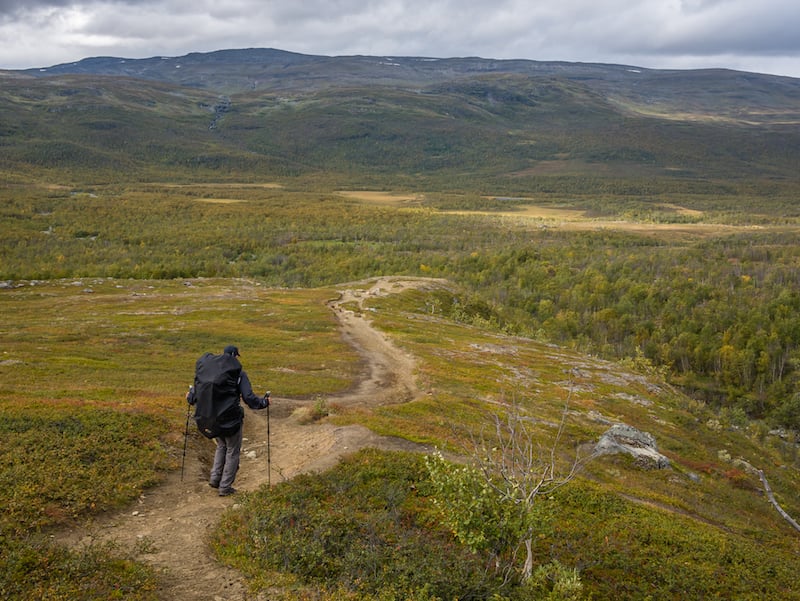
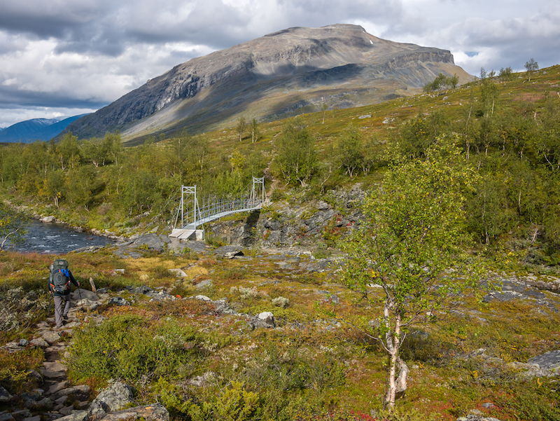
The 270-mile King’s Trail is well defined and easy to follow. With the exception of the Tjaktja Pass (the highest point at 1,140m), you will only be faced with modest height gains and losses. Hindrances include rocks, roots and boggy ground, so pay attention to your feet.
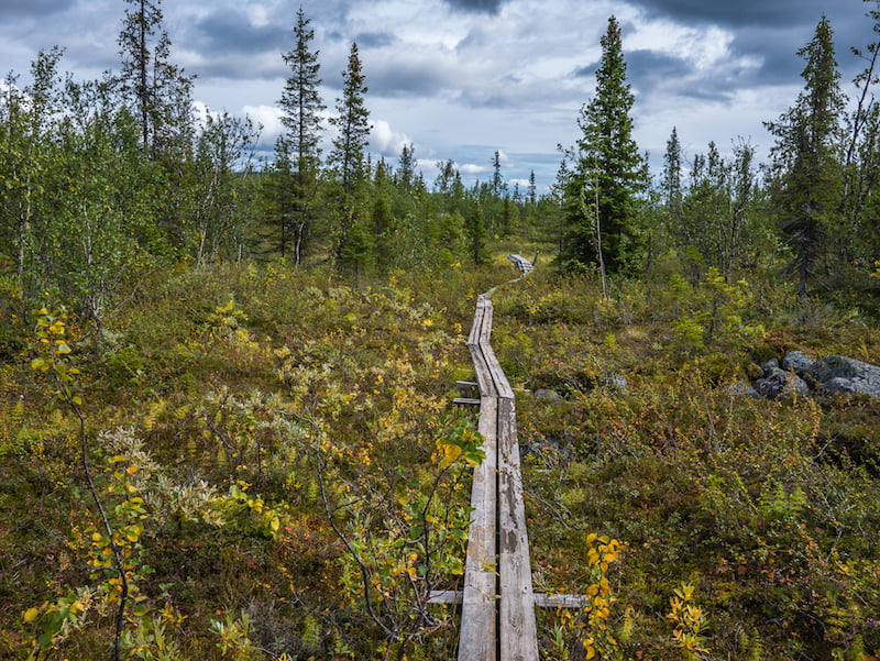
There are frequent wooden boardwalks, helping hikers over boggy terrain and minimising erosion, although some of these sections are in dire need of maintenance. Local charter boats (about £18), or rowing boats (free), get you across the several large lakes along the trail. Having experienced rain for at least a third of our trip, be prepared for cold, wet weather as the norm.
How to get to the start of the King’s Trail
There are direct flights to Stockholm from many UK airports. If you’re starting in Abikso and hiking south, an overnight train runs from central Stockholm through to Abisko (19 hours). It is also possible to fly to Kiruna from the UK, either direct or via Stockholm, which is much closer to Abisko. A train or bus the rest of the journey takes just over an hour. SkyScanner is a great place to find cheap flights.
Alternatively, if you plan to start from Hemavan in the south, internal flights from Stockholm to Hemavan and Tarnaby take approximately three hours, with low-cost Swedish airline NextJet. Due to timings and connections, allow for a travel day at either end of your trip.
When to hike the King’s Trail
The summer hiking season starts towards the end of June and lasts until the middle/end of September. If you want to witness the midnight sun, where you will have infinite daylight, then go before mid-July. However, if you want to avoid the worst of the mosquitoes, then go August to mid-September.
The northern section is considered the most scenic, but that means it is also the most popular, so huts can be crowded during the height of summer. Beware of snowfall late in the season as this creates a muddier trail and makes river crossings more difficult. Rowing boats are usually in place by the end of June/early July, but lake crossings can be hampered by severe weather.
How long does it take to hike the King’s Trail
Because of work commitments, we completed the whole trail in three weeks, but only try that if you don’t mind hiking long days (about 16 miles). A more realistic target is 28 days, and the trail can be easily separated into four segments, each representing about a week of hiking. You may also want to allow for some spare days should the weather, fatigue or minor injury hamper progress. We were advised that for every week on the trail you should add an extra day for the unpredictable weather.
Where to stay while hiking the King’s Trail
Sweden’s Allemansrätten, or freedom to roam, means you can wild camp anywhere you like, as long as you leave the surroundings undisturbed and follow the leave no trace ethic. A good rule of thumb is to pitch your tent out of sight of houses and do not stay more than two nights in the same spot.
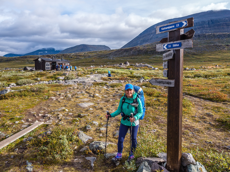
However, if you prefer a proper bed at the end of a long day, there’s a network of mountain huts along most of the King’s Trail, primarily operated by the STF (Swedish Tourist Association). The distance between the huts is typically between seven and 10 miles. The huts are simple, without electricity and running water, but comfortable, and are intended for self-catering. They sell basic food and medical supplies. You can camp outside a hut and use the facilities if you pay a fee.
Larger mountain huts, known as mountain stations, at Abisko, Saltoluokta, Kvikkjokk and Hemavan, have electricity, WiFi and hot showers as these are the main entry/exit points to the trail for section hikers. Some unmanned emergency shelters can also be found along the route, which are invaluable in extreme weather.
If you are tackling the entire trail, there are no STF huts between Kvikkjokk and Ammarnäs, about an 80-mile stretch, so you will need to carry a tent. Alternatively, private accommodation is available in Baverholmen, Adolfström and Jäkkvik.
What to take
If you’re staying in the huts, you don’t need to carry much more than a daypack, as you can buy food along the way and just need a sleeping bag. For the changeable weather, take a waterproof jacket and trousers. If you are intending to wild camp, make sure your tent will stand up to strong winds and wet weather.
Lots of layers are key to keeping warm, both when hiking and at night. Even in August, we awoke to frost on the tent. Walking poles are not essential, but they do help you manage a full backpack. They also give you support in boggy sections where there aren’t any boardwalks.