


Discover the Falklands on Foot
About the Author: Anna Smith
The Falkland Islands are some of the most unique places to hike on earth. You’re unlikely to meet another person outside of the capital Stanley, so it is just you and the wild, rugged landscape spilling out beneath your feet. These are our top pick of hikes for all levels across these beautiful islands.
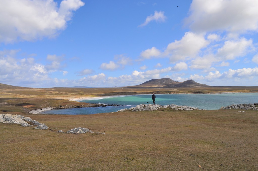
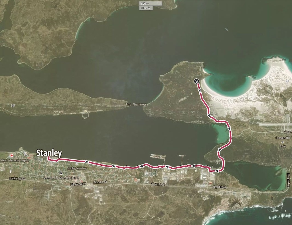
Stanley and Gypsy Cove
Distance: 8 miles
Time: 4 hours
Difficulty: Easy
For a taste of the capital (Stanley) and its gorgeous coastline, start at the Jetty Visitor Centre. Walk uphill a very short distance on Philomel Street, then turn left to walk in front of the Globe Tavern, along Crozier Place. Continue along Ross Road all the way to reach the Narrows Bar. If you need food or drink, stop in for a tipple with the locals or call in to the shop alongside the bar. There is no food or drink at Gypsy Cove.
As the road turns to the right, walk straight ahead along the coastal path in front of ‘Tussac House’ and follow the concrete path to the Seafarers’ Mission. Here there is a marked trail to ‘Gypsy Cove’. Walk along this narrow but well-trodden path alongside the coast. Though Stanley is a bright and open city already, the sky opens up here and the rugged countryside starts to roll in.
Cross the Boxer Bridge and walk along the road, up and over the hill, then down towards Whalebone Cove where the remains of the Lady Elizabeth shipwreck lies. Still balancing on its hull, this strange sight has been petrified on the beach since 1936 after a storm blew her from her mooring.
Follow the coastline in front of the shipwreck until you spot the sign for Gypsy Cove at the top of the hill. Turn left and follow this road all the way to the Gypsy Cove parking area.
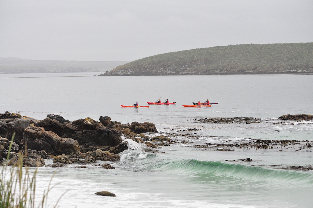
Spend some time in the cove on the sheltered white sand beaches, amongst the rock pools and with the friendly penguins. There’s ample opportunity whilst in the Cape Pembroke Peninsula region to kayak, along with plenty of other fun coastal activities.
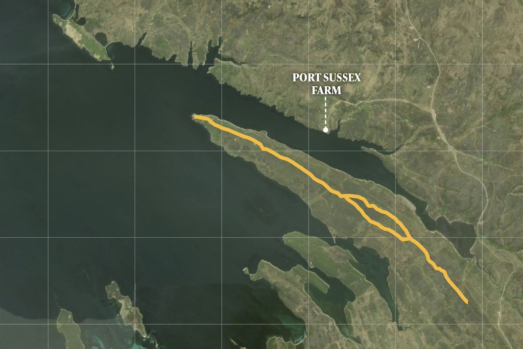
Whale Way; Port Sussex
Distance: 8.4 miles
Time: 3-4 hours
Difficulty: Moderate
In the west of East Falkland there’s a gash in the land that looks like a giant, mythical tiger took a swipe out of the earth. In the most northerly of these inlets is Port Sussex. This stunning bay stitches together the water, the land and the sky to create a tapestry of the Falklands like no other.
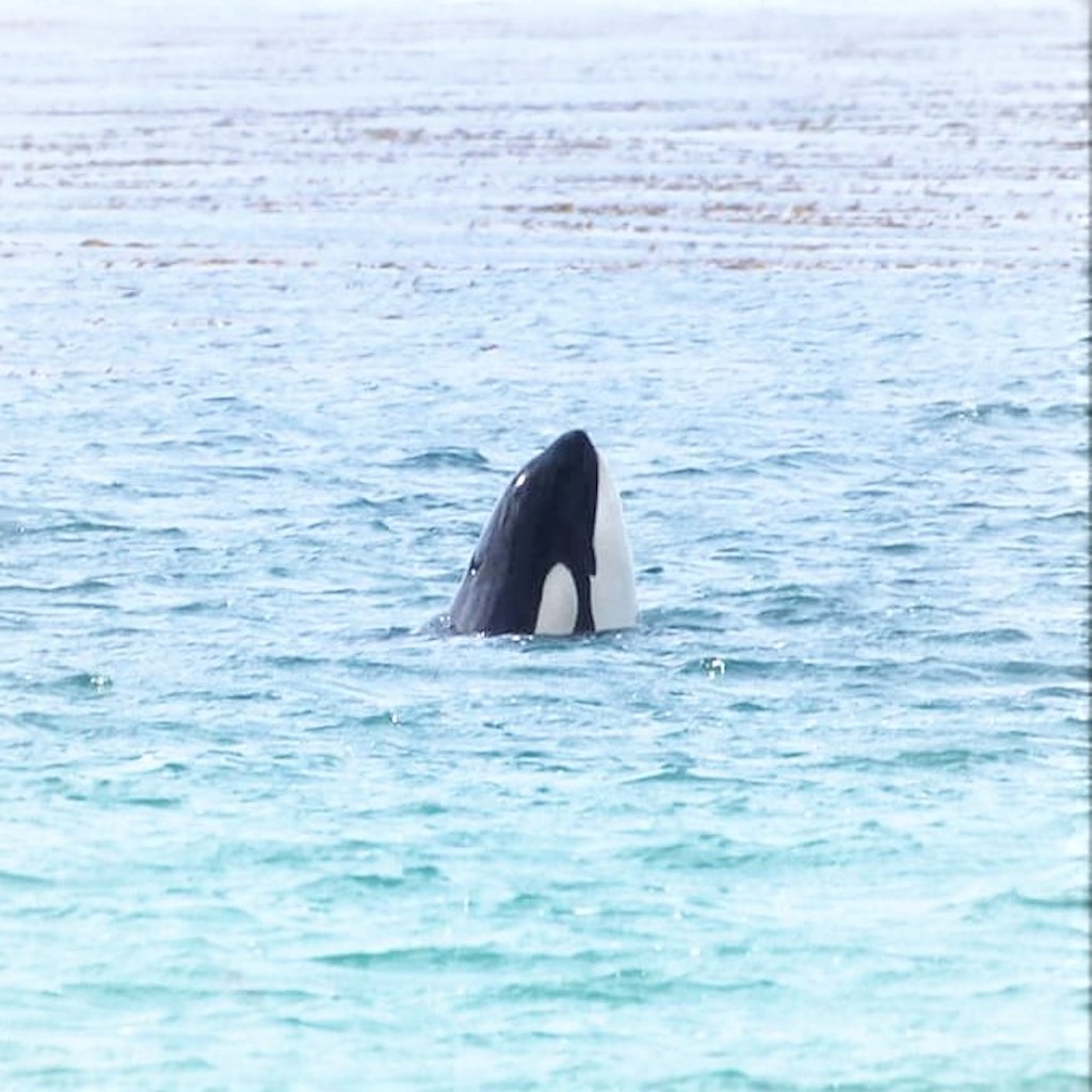
The Whale Way is an out and back hike that bathes you in this merging of the elements. As the name suggests, it is the perfect walk to spot some marine wildlife. Whilst whale sightings are never guaranteed, the way the headland leads you out to sea means it is not uncommon to spot a blow out of the water or another creature making their gentle way along the coast.
Mostly along vehicle tracks, it’s a social walk through the local farms. Port Sussex is also great for fly fishing, though make sure you have the relevant permissions.
The Whale Way is a very manageable hike, however, there is a necessity to navigate balsam bog heath should you lose your way. Equally, the ever-changing weather and wild winds of the Falklands, especially on the headland, requires walkers to be confident identifying tracks.
To reach the trail, drive from the east past Port Sussex Farm until you see a large metal stockade. Make your way over it and follow the fence to your right. Then, whenever you come to a fork, head left until you reach the tip of the headland and its panorama of hills, mountains and wild seas.
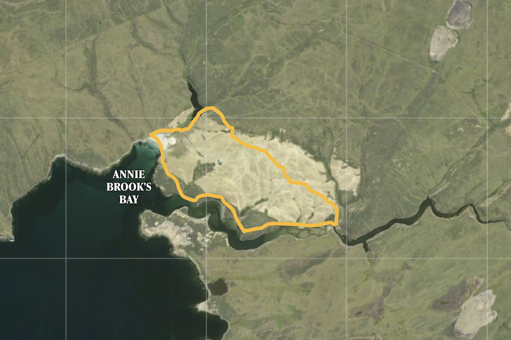
Sand Pond & Stream Trail
Distance: 11 miles
Time: 5-6 hours
Difficulty: Moderate
Fox Bay is of great historic significance in the Falklands, from its name sake, the now extinct warrah (Arctic wolf), to its role in the 1982 war, and the trilobite fossils that lie dormant in the rocks below your feet. A hike in this region offers not only a stunning walk but a journey through time.
Make your way to Annie Brooks Bay and spend some time soaking in the scenery before heading east uphill. There is no set path, simply cross the otherworldly heath with the shoreline to your right. About two and half miles in, you’ll stumble across a memorial for a local man named David, inscribed with the words ‘David’s Place’. Take a moment to appreciate the many people and animals who have shaped the Falklands to be the remarkable place it is today.
For a spot of fishing, carry on up-river from ‘David’s Place’, before returning back along the vehicle track. This stretch of the walk feels like wandering into a barren desert, with the mirage of West Head in the distance. Head forward until you see Annie Brooks Bay to the left once more and go downhill to Bottomless Pond, along the coast, and back to the settlement.
This is a peaceful walk on the lesser visited West Falkland and is the perfect way to get to know the islands as they have been for centuries; rugged, full of wildlife and extremely special.
North Point Circular
Distance: 13 miles
Time: 5-7 hours
Difficulty: Moderate/Difficult
The Falklands are famous for many things, but the main one is penguins. There are one million penguins on the islands during the summer and they are excellent hiking pals. Though, whilst they are in the spotlight, visitors shouldn’t miss out on the other fabulous, feathered inhabitants.
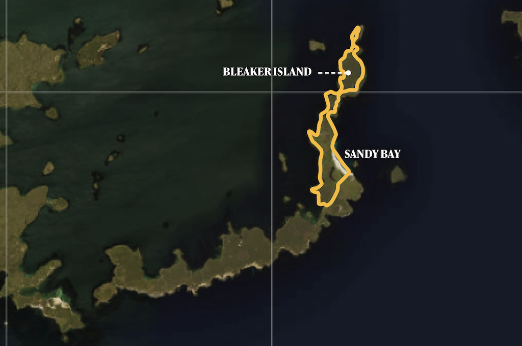
The North Point Circular on Bleaker Island is perfect for birders. A National Nature Reserve, there are myriad opportunities to spot more than 40 different breeding birds, including Magellanic, southern rockhopper, and the friendly gentoo penguins on Sandy Bay. You’ll also find Chiloe widgeons, black-necked swans, and the endemic Falkland steamer duck.
The wonderful thing about circular, coastal walks is as long as the sea stays the same side of you, you’re going in the right direction. We recommend heading along the west coast, leaving the settlement via the wind turbine and towards the shearing shed. Highlights include the shipwrecks near ‘second neck’, the rock cormorant and steamer duck habitats before ‘third neck’, the sea caves at North Point, and the walk along Sandy Bay.
It is a very flat walk with varied terrain and, although it’s considered quite difficult, it can be shortened easily by following the tracks that deviate from the coast or by heading to the opposite shore at one of the island’s ‘necks’ back to the settlement. You can reach Bleaker Island with the Falkland Islands Government Air Service.
Visit www.falklandislands.com to start planning your trip.

