

RIVER DEEP, MOUNTAIN HIGH
An island of EXTREME highs and sweeping lows with plenty to EXPLORE in between, subtropical MADEIRA is an adventurer’s PARADISE
 Ehhh… take it eaassy senhor,” says our guide Rui, thumping me hard on the back. I double over in fits of sustained coughing.
Continuing to thump me, he makes a fist with his other hand and shakes it heavenward with an ear-spanning grin. “That’s why we call it Poncha, my friend, because it really packs a ‘poncha’!”.
Witnessing the results of over-eager consumption, my girlfriend, Lydia, lowers the glass hovering at her lips. As I give her a warning look through watery eyes, her face is lit by the intense orange glow of the radioactive-looking liquid. “Don’t worry, Lydia,’’ says Rui.
“Poncha à Pescador is a medicinal drink that has been used by fishermen here on the island for centuries. The vitamin C from the oranges helps stave off scurvy, and the 50 percent alcohol content warms you up on a cold night.” “Rui,’’ I say, slowly regaining my ability to speak. “It’s 9.30 am and 22 degrees outside.”
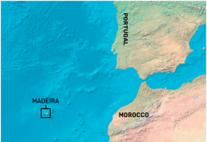
When Portuguese explorer João Gonçalves Zarco discovered the island of Madeira in 1420, he described the looming cliffs of the archipelago towering above the bows of his galleon as being ‘akin to the gates of hell’. In stark contrast, when Lydia and I first spied the island through the plexiglass windows of the EZY446 from Gatwick last December, after nearly 12 months of lockdown in a pokey London flat, we rather thought those towering sun-drenched cliffs resembled the pearly gates of Elysium. I suppose it’s all about context.
OVERLAND
Upon arrival at Cristiano Ronaldo International Airport, we are met by our guide, Rui Silva, from True Spirit tours. Although hiking is our primary objective in Madeira, we’ve decided to maximise cultural immersion levels by booking a one-day, whistle-stop, full-island tour by enlisting the services of a local expert off-road driver. “Welcome to Jurassic Park,” laughs Rui as he helps load our bags into the convertible Land Rover. “How was your flight?” he enquires, knowingly (landing at the airport is a notoriously terrifying experience owing to a short, precipitous runway overhanging rough seas). “Quite fruity, thanks,” replies Lydia, bumping elbows with him pandemic-style. “Great,” says Rui. “Madeira is 13 miles wide and 35 miles long, so we’d better get some wiggles on.”
Ponta de São Lourenço is our first stop on the island, 9 miles from the airport out at the extreme eastern tip. After clambering from the 4×4, we are met with a unique perspective. Craggy as you like, the jagged red-and-black basalt cliffs stand defiant before an angry ink-blue sea. Like the fin of a mean, old shark they cut towards the horizon and sink dangerously into the deep. “I’ve never seen so much motion in the ocean,” says Lydia as we watch a group of seabirds bravely pick fish from the water’s edge, negotiating bungalow-sized waves in the process.
“Do you prefer little tarts or big tarts?” asks Rui as he opens a Tupperware brimming with an assortment of Pastel de Nata (emblematic Portuguese pastries). “You may think one’s enough, my friends, but only if you’ve never tried one.” He’s not wrong. There’s something desperately delicious and addictive about the combo of smooth, blistered, caramelised custard, encased in flaky, golden-brown puff pastry and dusted with cinnamon and icing sugar. I sink three in as many minutes; Lydia does the same.
As we negotiate spaghetti roads, lofty flyovers, and long tunnels toward our next destination, I marvel at the infrastructure of the island. There’s not an inch of flat ground to be seen. “Our government has won many prizes for engineering,” says Rui proudly. “Before these crazy roads were built, getting around wasn’t easy.” After 45 minutes cruising the ocean roads along the island’s south coast, we hang a right. Suddenly, all we see is sky. The Land Rover groans in response to the now-45-degree slope. “This is the Rua da Barreira,” says Rui. “One of the steepest roads in the world.”
After an hour of slightly nauseating driving, we arrive at Paul da Serra Plateau, high up in the eastern interior. The midday sun beats down as Rui leads us from the bright car park into a dense forest. Giant wizened trees, like something out of the pages of a Tolkien novel, surround us. Rui explains how the ancient Laurissilva (Laurel) forest of Fanal is UNESCO classified, many of the trees being over 1,000 years old. I walk up to a particularly gnarly looking specimen and place my palm on the bark, trying to get a better sense of its majesty. “You should see this place in the fog when the trees are silhouetted,” says Rui. “There’s a real danger of disorientation, people get lost up here all the time.” Even without the fog, the ancient woodland is a photographer’s dream.
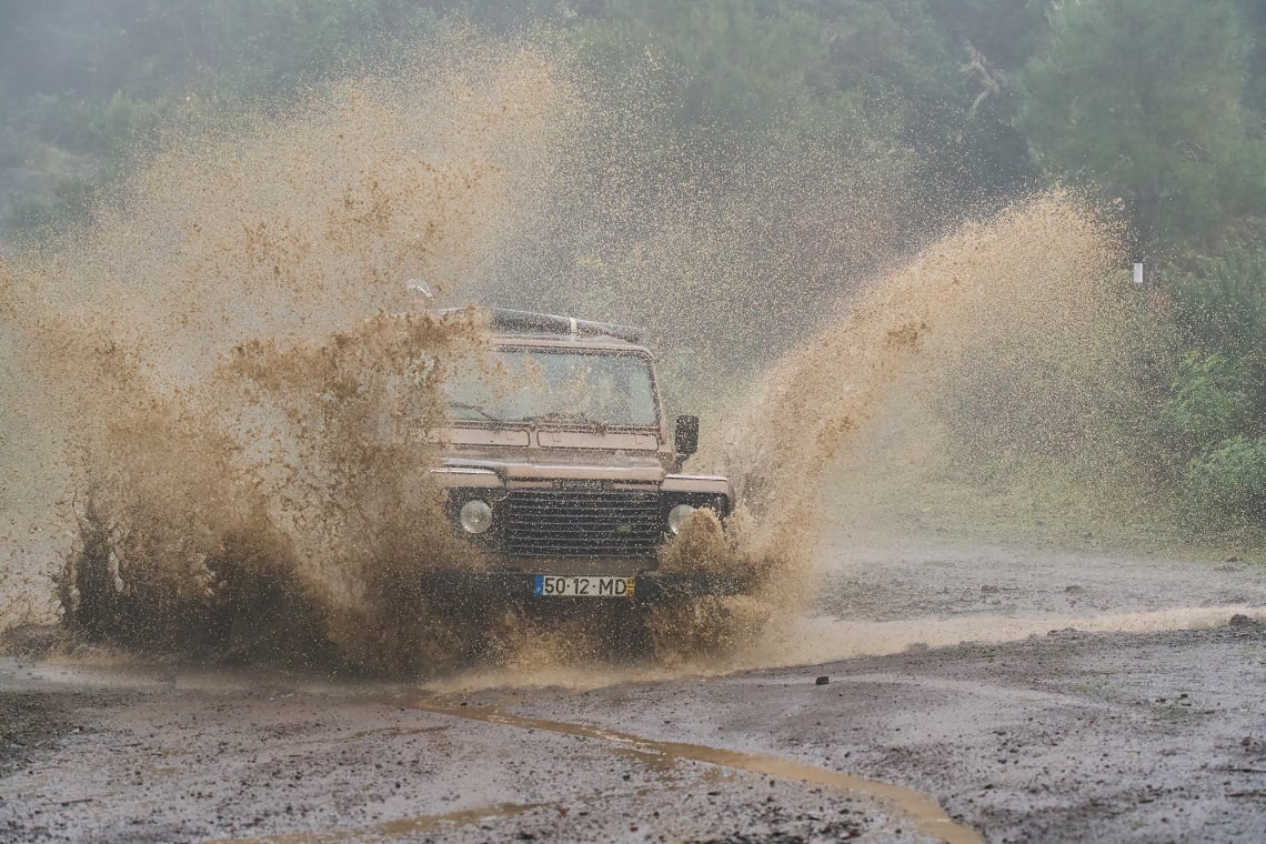
Over the course of the afternoon, we scream through sub-tropical-jungle like legendary rally driver Colin McRae, across gravel, mud, rocks and riverbeds — the ‘old roads’ as Rui calls them. He pays particular attention to the cavernous puddles, a Madeiran staple, insisting that I get out to take pictures as he smashes through them at speed, sending tidal waves of brown sludge high into the air. Poor Lydia stands up in the back, hanging on for grim death. We laugh our heads off at the simple pleasure of it, stopping to dry ourselves and soak in the many rugged panoramas along the north coast.
STAIRWAY TO HEAVEN
The next morning, as we shoulder backpacks and sip coffee from a flask in pre-dawn light, the twinkle of a head torch approaches, oscillating across the carpark. “Bom dia,” says a lithe-looking gent trotting up to introduce himself. “I’m your guide, Daniel Ferreira, from Go Trail.” It’s clear that Daniel is a man of mileage. His calf muscles resemble ripe mangos and a large vein snakes through light stubble below the chin line. He’d called us at the hotel the night before and insisted on starting before sunrise.
Today’s trail was the one we’d come for. Bang in the mountainous heart of Madeira, 45 minutes’ drive north from the capital Funchal, the PR1 charts a course between the islands two highest peaks — Pico do Arieiro (1,818m) and Pico Ruivo (1,862m). On the drive from the hotel at sea level, a thick layer of cloud had us thinking we were doomed. Magically, at 1,800m, we’d popped up above it into a starry scene of silver and blue. “Shall we?” asks Daniel striding nimbly across the moonlit tarmac.
After easy strolling down from the peak below a radar station the view opens up, and what a view it is. Sun spills over the oceanic horizon, drenching us in a honeyed morning light. Daniel points out Curral das Freiras (Valley of the Nuns), a small village far below, situated in the crater of an extinct volcano.
Rumour has it the Santa Clara Convent at the heart of the village was, in the old days, a hiding place for nuns fleeing from marauding pirates. As I survey the valley and beyond, I understand why. There’s nothing but densely forested and inaccessible mountains, erupting in all directions. The perfect place to avoid becoming a hot commodity in the 16th Century slave trade.
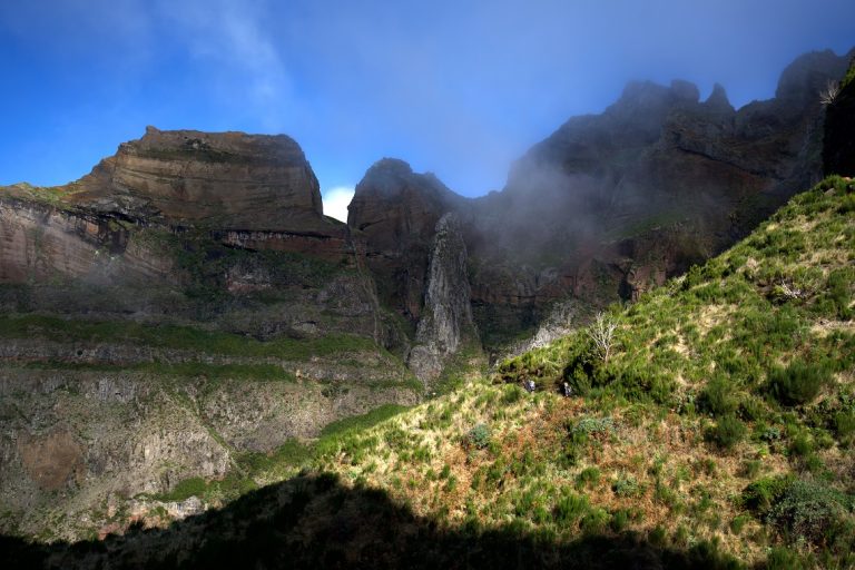
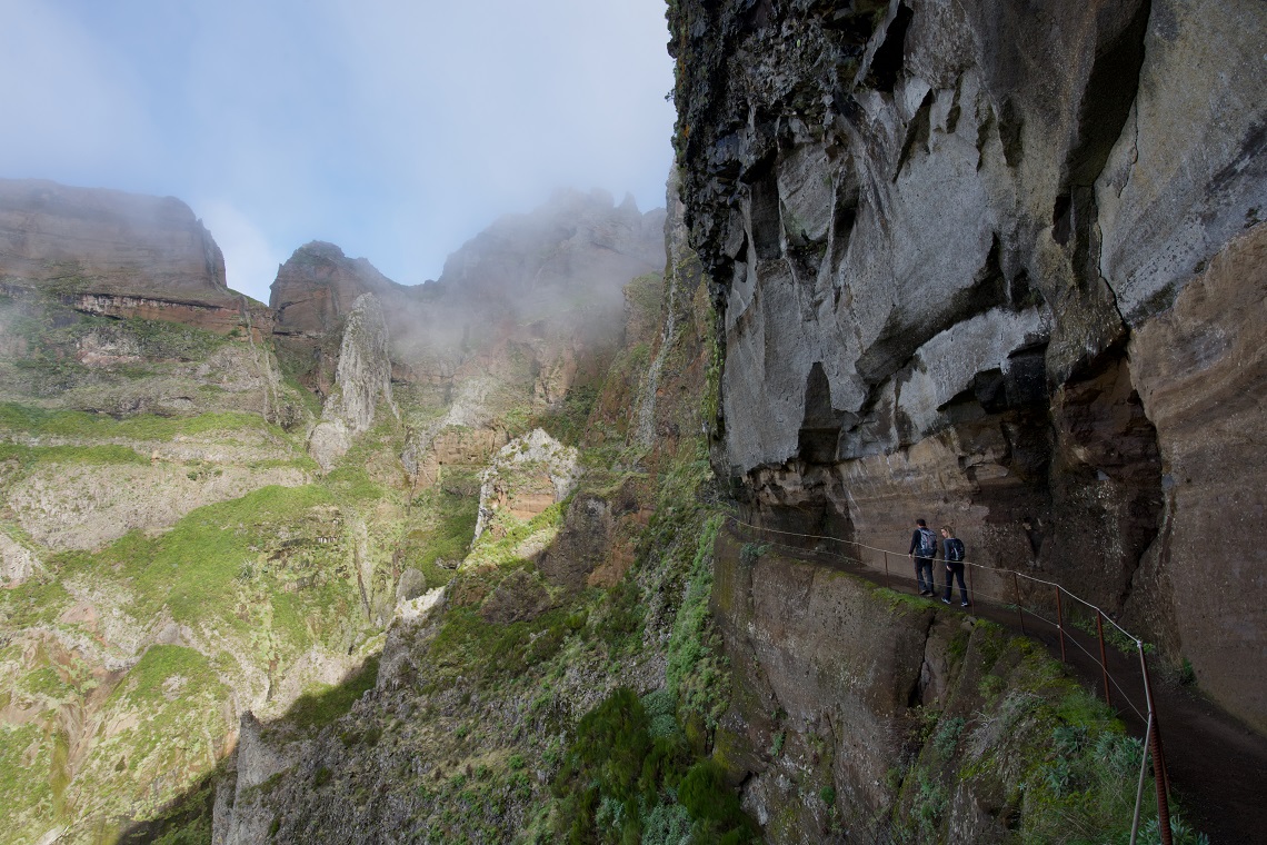
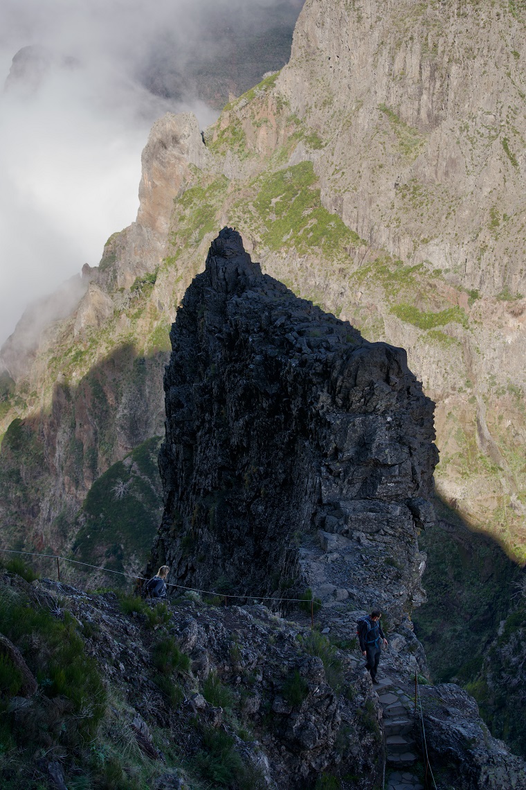
After a quick stop at Ninho da Manta (Buzzard’s Nest), a small wooden observation deck overhanging the first truly unobstructed eye-candy view, we continue on. Soon we reach the Instagram section of the trail: an exposed staircase, perfectly balanced upon a knife-edged ridge. Despite the stairs being even and well maintained with timber handrails, the illusion of danger is enough that we get a lovely stomach-stirring buzz as we climb.
Further on, things steepen and we start to puff. Daniel explains how this, the most famous hike in Madeira, was never intended for tourists. It was originally built by, and for, shepherds to herd their livestock between pastures on opposing sides of the mountain. He points to evidence of the trail’s pastoral heritage in the form of chiselled-out caves, explaining how farmers would sleep within, surrounded by their sheep for warmth. ‘Rather them than me,’ I’m thinking.
We continue on the undulating trail for a few minutes before arriving at a man-sized hole in the wall. “Put your head torches on, chicos,” says Daniel. “It’s time for ‘Pico do Gato’, our first tunnel.” A dank waft of air escapes from the darkness and after a last look across the mighty vistas to the south, we follow him in. At over 150m long, the rocky passageway, which looks to have been blasted out of the mountain, makes me feel like a Gold Rush prospector. Our footsteps echo in the darkness. I decided to test the acoustics and shout “Oi-Ooooi!” like a yobbo at the top of my lungs. It creates a satisfyingly antisocial echo. Lydia gives me ‘the look’ and we stride on.
Moments later Daniel, ever the optimist, points directly ahead. “Look,” he says, “There’s a light at the end of the tunnel.” We emerge from the opening and an entirely new panorama
awaits us. Admiring the colder, more tempestuous northern fringes of the island I realise the unique pleasure of a mountain tunnel: two completely opposing views in as many minutes.
Those ancient sheep-herding path-builders really didn’t mess about, as is evidenced from the next part of the trail. A perfectly cylindrical channel has been furrowed out of the wall almost as though a giant butter knife has descended from the sky and ploughed into the rock. Enveloped by the basalt tube, we continue. Next, come a series of vertical metal ladders, or as Daniel likes to call them, ‘staircases’. The going gets tough here. My Garmin lets out its first proper cry of approval, my heart rate skirting the orange zone. At the top of the final staircase, we’re presented with a sight that must be one of the all-time greatest views my optic nerve has ever delivered to my tiny brain.
Cloud sits heavily in the valley below, bathed in ultraviolet, as layer upon layer of dark, forested mountain ridges hunker like tree roots. The root-esque ridges seem to anchor the Central Mountain Massif into the sky. “Let’s break for lunch,” says Daniel, dishing out a selection of vivid and lavish local fare.
Yellow flowers line the path to the summit of Pico Ruivo. As we climb through a particularly atmospheric area of petrified forest, Daniel explains how a fire once devastated the mountain. Although the event caused the destruction of much flora and fauna, I can’t help but enjoy the surreally smooth sculptural trees, burned white amid the deep green. It’s not long before we’re on the summit. By way of celebration, I dig a few more Pastel de Nata out of my bag and promptly demolish them, feeding the last few crumbs to a particularly exotic-looking chaffinch. After bumping elbows and posing for a team photo, we survey the area.
Above the clouds, as we have been all day, 360-degree views give us a real geographical feel of the island. “From here you can see the Ilhas Desertas ‘Desert Islands’” says Daniel pointing to a black shadow on the horizon. “They are part of the Madeiran archipelago and a designated nature reserve; the last refuge of the rarest seal in the world, the Mediterranean Monk.” Even from several miles away, it looks like the Monks have picked a good spot to hole up.
Although we’re now at the highest point in Madeira, the journey back is by no means downhill. We pick up another 500 fearsome meters of incline on the return leg, which means a total of 1,000m or the day. The final mile or so back to Ninho da Manta is 100 percent uphill. I find myself feeling old, bringing up the rear and wheezing like an aged pug. Different lighting conditions and fast-changing weather systems mean the final stretch is even more epic on the way back. My knees are hating me when we reach the finish, but my mind is full and pleased.
THE LOWDOWN
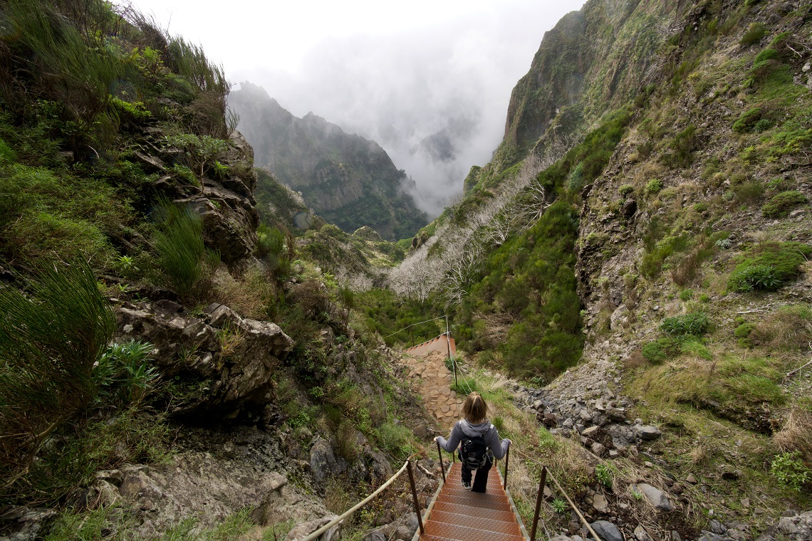
Madeira’s famous Levada waterways, a 1,350-mile network of slimline concrete rivers that span the island, were masterminded by the Moors in the time of Al-Andalus (711-1492). Built as a solution to the then-irrigation problem, the warmer, drier, southeastern shore was more conducive to habitation and agriculture with a constant supply of life-giving H²O from the wild and weather-lashed northwest. Good news is, not only did those canny Moors solve the irrigation problem by building the levadas, they also created a welcome bi-product; an extensive network of hiking trails through the island’s remote countryside. Arguably the most famous of said hiking trails is the PR6 25 Fontes in Rabaçal, upon which our sights were set for the final day’s adventuring.
Arriving at one of the most scenic car parks you’ll ever skid through, we salute our guide for the day, Goncalo Vieira, from Madeira Experience Tours. Goncalo, much like past guides Daniel and Rui, is a chilled but dangerous-looking Madeiran cardio fiend, tanned and bearded, undoubtedly well-versed in the ways of the wilderness. When the dust from my handbrake urn settles, he smiles and points. “That is the valley we will be hiking. It will be gentle and refreshing compared to your day on the mountain.” I catch Lydia’s eye and exhale in relief. Rui had gifted us a bottle of Poncha, which we’d polished off the night before.
The first thing I notice is the sheer quantity of gravity-borne water that surrounds us. It’s not only coursing gently along the levada beside us, it’s also dripping from the many leaves and branches above, and leaking from the mountain wall rising to our right. Small tributaries even spill across the path in places, flowing downwards toward the sea. The sound of water in every form laps at our eardrums; rush, trickle, drip, splosh. Thick moss and lichen of all varieties cling and hang in the floral-scented and highly oxygenated maritime air. Everywhere we look, it’s luscious and moist.
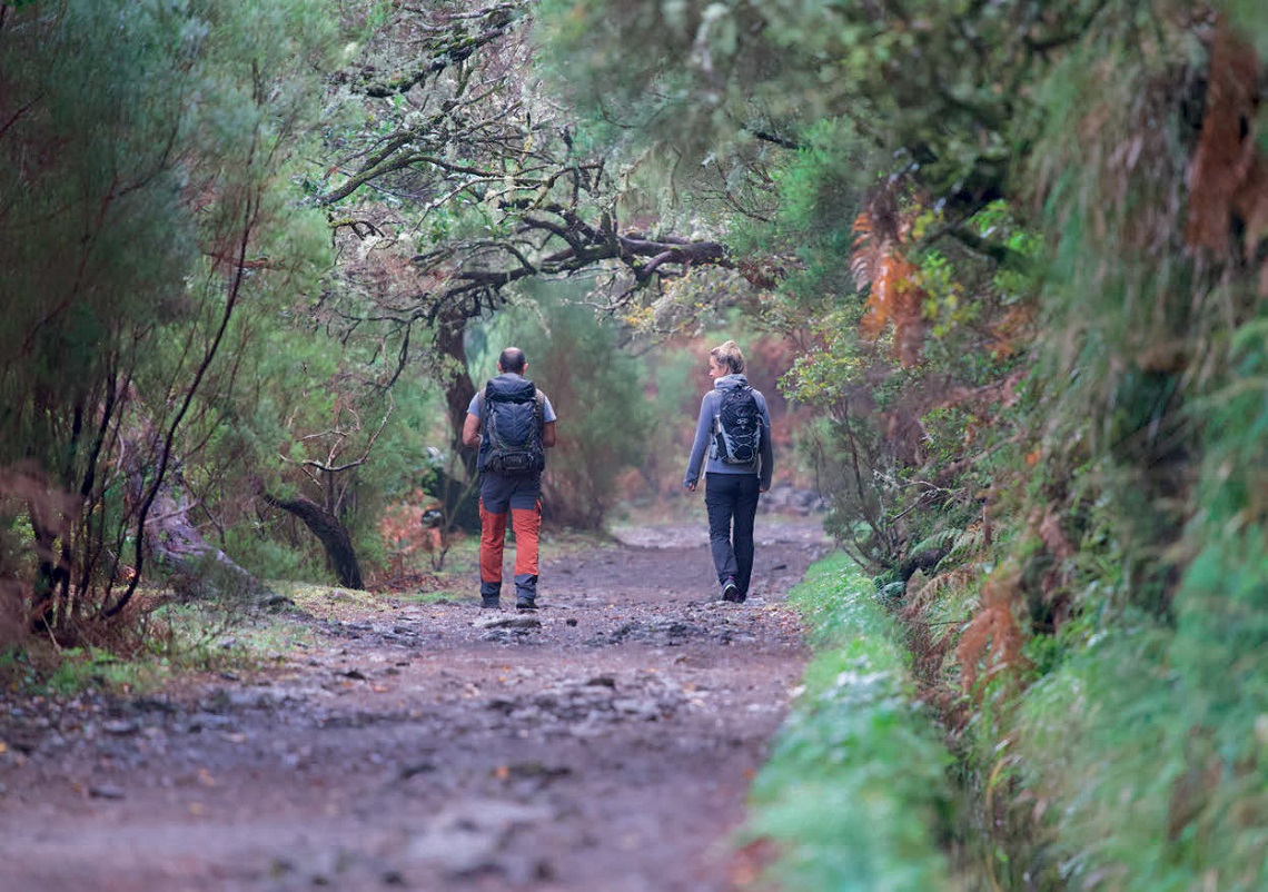
Soon the forest starts to overwhelm the trail. Laurel trees reach toward each other above us creating Tim-Burton style gothic tunnels and some truly stunning visuals. “Do you enjoy a splendid cascade?” asks Goncalo in a mock-British accent. “Not half,” I say as we round the corner and enter the clearing below Risco waterfall. “After heavy rains this one really booms,” he says. “There used to be a trail underneath but landslides destroyed it.” The single high-pressure torrent is flying into thin air on the horizontal and hum-dinging toward the forest below.
Next, we enjoy a downhill section of path, which Goncalo assures us we’ll pay for on the way back. There’s an unexpected quantity of people vying for position around us but as is the norm in Madeira, it’s good vibes all around. Keeping eyes active we observe many lizards, butterflies, bees, vibrant foliage and even catch a fleeting glimpse of the endemic Firecrest (Europe’s smallest bird).
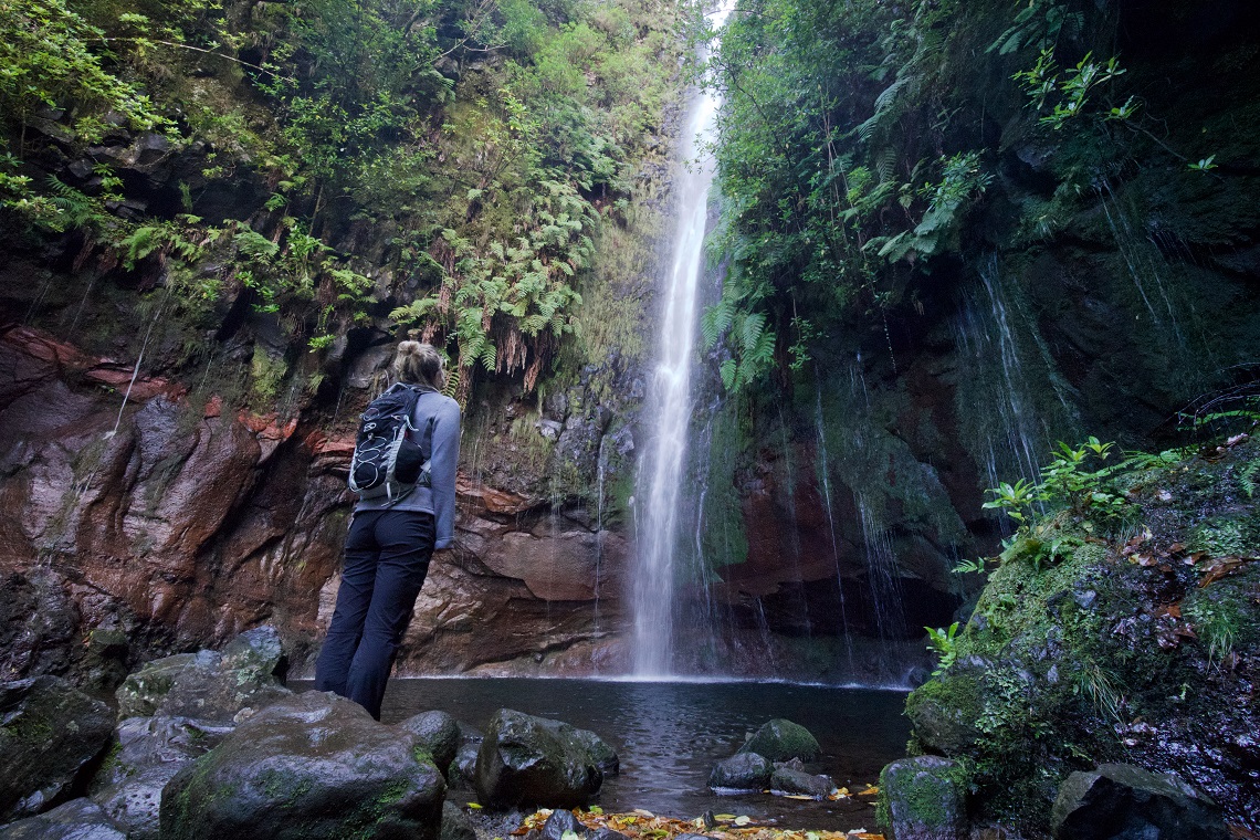
With 3 miles behind us, we finally down tools and put bums-to-boulders at the edge of a glassy lagoon below the 25 Fontes, aka ‘The Weeping Wall’. Sadly, I’ve run out of Pastel de Nata, so I unwrap a KitKat, open my mind, and take it all in. Vines and succulent plants drape down the facade of the small dark amphitheatre. Light creeps over the cliff above, and thanks to recent December rains, the falls are gushing nicely.

Goncalo has us count all 25 Fontes (sources) which proves there really are that many. “Who’s going swimming then?” he asks, pocketing his hands and leaning lackadaisically back against his pack, pulling his hat over his eyes like a wearisome cowboy. Having tested the water with fingertips moments before I’m only too aware of how intensely nippy it is. Rolling up my trousers I content myself with a refreshing foot spa — like any brave adventurer would.
Sunny and warm all year round, Madeira is one of the most comfortable yet intrepid places I’ve ever explored. Safe, sub-tropical, and covered in rich volcanic soil that supports all manner of interesting endemic life.
We were there in December and can attest to the party spirit burning bright. The fun doesn’t stop there either. Grandiose mountains, fortified wines, deep, dark-blue oceans, and a cool coastal breeze…. If you enjoy a bit of eat, sleep, hike, repeat, look no further. We stayed at hotel Galo Mar and lived like Bond villains for around £50 a night… oh, and try the Scabbard fish with bananas, sounds so wrong but tastes so right.
WHO’S WRITING?
 Maxwell Roche is a journalist/incongruous caveman who spends much of his time in antiquarian bookshops taking great-long sniffs. He also hurls himself off, down, or into anything for a story or a photograph, travelling in search of a view, because it’s all about the view. He’s a desperate skydiver, addicted surfer, and frivolous cyclist, horrified by the prospect of missing out and tormented by indecision regarding his future.